Late evening on October 3, 2013 Juston Drake and I documented a tornado near Panama, NE. The Omaha/Lincoln NWS Office later determined the tornado had a 16.5 mile long path with EF2 damage, and a maximum width of 300 yards. The tornado affected several farms, but fortunately missed several towns passing north of Panama, south of Bennet, and west of Palmyra.

Tornadic Supercell Northwest of Panama, NE on October 3, 2013
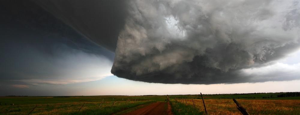
Multivortex Cone EF2 Tornado South of Bennet, NE October 3, 2013
The following day, October 4th, we chased a significant tornado outbreak affecting parts of Nebraska, South Dakota, and Iowa. Click on the video below to view a short clip from our chase showing the massive Wayne, NE EF4 tornado:
Our initial target was Northeast Nebraska and Northwest Iowa. A very intense trough/mid-level closed low was progressing over the Northern Plains. This trough would provide significant upper-level lift for the formation of vigorous updrafts, cold mid-level air for enhanced instability, and deep-layer shear for powerful supercell storms over the Central Great Plains.

4th October 2013 22Z 700mb Analysis
Deep tropical moisture over Kansas and Missouri, which helped fuel storms the previous night, was advecting northward into the area. At the surface a primary warm front was retreating over northern Nebraska and Iowa, a pseudo warm front/deep moisture boundary was retreating north of the I-80 corridor. A modified Pacific cold front/dryline boundary was progressing over the Eastern Plains with a noticeable bulge southwest of Omaha. Storms north of the bulge would be more likely to be isolated with a storm motion nearly perpendicular to the dryline boundary. Storms south of the bulge were more likely to be outflow dominant/elevated with a path nearly parallel to the boundary.

4 October 2013 2143Z Surface Map Analysis
A relatively warm layer of air near 800mb was overriding the warm sector from the Southwest providing a strong, but breakable capping inversion. This CAP held off widespread convection throughout most of the day over the warm sector. Also, a widespread upper-level clear slot moved over the Central Plains maximizing daytime surface heating. Instability dramatically increased over Northeast Nebraska and Northwest Iowa as the day progressed. Between 1000-3500 J/kg of surface-based CAPE was developing in the region–the actual amount of CAPE can only be estimated, because mid-level temperatures were cooling very rapidly from cold air advection and significant upper-level lift.

2215Z Watervapor Satellite Image Analysis from October 4, 2013

18Z Modified Omaha, NE Upper Air Sounding on October 4, 2013
The deep layer wind shear north of the dryline bulge was incredible and the low-level shear was nothing short of amazing. 0-1km, 0-3km, and effective layer storm-relative helicity values were between 200 and 600 m2/s2. The surface low was located near O’Neill, NE and not just one, but two warm front boundaries were in the area of interest–it shouldn’t be a surprise relatively high surface vorticity values were being analyzed. The combination of high shear and instability over northeastern Nebraska and northwestern Iowa was similar to any high end tornado environment. The effective layer EHI’s (Energy-Helicity Index) values ranged from 3 to possibly as high as 13 (most likely near 8 or 9) over the region when the event was unfolding.

22Z RAP Mesoanalysis on October 4, 2013: 0-1 EHI’s, Effective Layer Helicity, 0-3 CAPE & Surface Vorticity, & SFC-Based CAPE
Juston and I were northwest of Freemont, NE when storms began developing to our West and Southwest along the dryline. We decided to intercept a small cluster of developing updrafts near Columbus–they were moving into an environment conducive for strong tornadoes. Updrafts to the southeast were struggling, which kept the low-level flow going into our developing storm virtually untapped.

2045Z Visible Satellite Image on October 4, 2013– developing tornadic supercells can be seen over northeast Nebraska
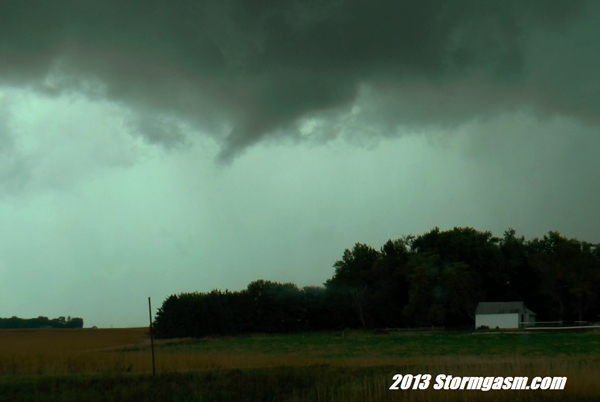
We intercepted the now strengthening storm south of Stanton. We could see the updraft base was rather elongated. A second updraft base was to its south; soon we witnessed a long and slender rope landspout tornado develop under this southern base as we sat waiting for a pilot vehicle in construction south of Stanton (why does it seem construction crews are so active during major severe weather events?). The tornado dissipated and we continued north on sandy roads out of town as the two updrafts began the sloppy process of merging. About 12 miles southwest of Wayne the supercell quickly organized–developing inflow bands, a large base, and a huge RFD clear slot. Soon a large bowl funnel appeared to our WNW, and in less than a minute we could see condensation vorticies touching down under the massive funnel cloud. Only moments later the tornado took on a wedge appearance.

Large tornado developing southwest of Wayne, NE on October 4, 2013
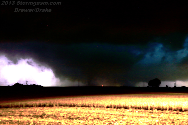
The rotating debris cloud near the surface was nearly twice the size of the visible condensation of the wedge tornado indicating a much larger and more significant tornado vortex. The scene forced us to immediately recall relatively fresh memories from the developing stages of the massive 2.6 mile wide El Reno tornado earlier this year. The base was gargantuan, the debris cloud was huge, and what would typically be a large wedge-shaped condensation funnel in contact with the ground appeared small. We repositioned southeast of Wayne as the tornado rapidly grew giving it a little more room during its intensification process.

Large Multivortex tornado forming south of Wayne, NE on October 4, 2013. Notice larger debris cloud surrounding condensation vortex indicative of a much larger tornado

text-book supercell structure with massive EF4 wedge tornado near Wayne Nebraska on October 4, 2013
The tornado briefly became wrapped in rain and we were soon floored by the spectacle before us–a monstrous megawedge tornado dominating the western horizon. I can only compare what was unfolding before our very eyes to the 2004 Hallam, NE and 2013 El Reno, OK tornado events. I have to say I was very surprised at what was occurring; we felt the conditions were conducive for several long-track strong to violent tornadoes, but this was on an entirely different level.

Massive EF4 wedge tornado near Wayne, NE October 4, 2013

Monstrous EF4 wedge tornado approaching 2 miles wide near the town of Wayne, NE on October 4, 2013

2219-2231Z Base Reflectivity Images from Omaha showing Wayne, NE supercell when tornado was ongoing–notice large debris ball & vortex hole in the final image indicating a very large tornado

2219-2231Z Storm Relative Velocity Radar Images from Omaha showing strong rotation couplet with Wayne, NE supercell when tornado was ongoing
We followed the massive tornado as it tracked north-northeast at nearly 30 mph. Approximately 2 miles southwest of Wakefield we saw a cone funnel quickly develop along the RFD gust front. Debris lifted into the air as it passed over a field and we could see it was an anticyclonic tornado (anticyclonic tornadoes rotate clockwise in the Northern Hemisphere).
Dissipating funnel cloud from anticyclonic tornado SW of Wakefield, NE on October 4, 2013
After the anticyclonic tornado dissipated, a new wall cloud developed east of the now rain-wrapped Wayne tornado. We had been steadily losing ground on the storm, so we decided to make a significant reposition to the northeast in an attempt to beat the storm to the Sioux City, IA area. As we approached Sioux City another supercell to our South was rapidly intensifying and would soon cause problems for our storm. We immediately dropped our storm, even though it was still producing tornadoes, and punched east through the outer fringes of the new tornadic supercell. We positioned about 10 miles northeast of the updraft near the town of Quimby, IA. The amazing striated rotating updraft of the Pierson tornadic supercell was bearing down on us. There were reports of a large damaging tornado, but heavy rain under the meso made it impossible for us to see a tornado.

Image of incredible supercell structure from Pierson, IA tornadic supercell shot several miles W of Quimby looking SW
As the supercell quickly approached our location, we drove east of Quimby, letting it pass to our northeast. As night fell more storms began to develop to the south. We sat on the south side of Storm Lake, IA and watched the southern-most storm pass to our northwest. We tried, but failed, to see a possible tornado backlit by lightning as the storm passed. The Sioux Falls NWS Office later found a 5.45 mile long EF1 damage path with this storm northwest of Storm Lake near the town of Alta.

NWS Prelim Damage Survey Map with Juston and Simon’s chase path and notes from October 4, 2013
This outbreak was significant regardless of the time of year. There were 5 significant tornadoes: 3 were long-track, 2 of these caused EF4 damage and were unusually wide–both at or exceeding 1.5 miles at their maximum width. The Omaha/Lincoln NWS Office determined the Wayne, NE tornado had a 19 mile path length, a maximum path width of 1.38 miles (disputed), caused 15 injuries, and caused EF4 damage to an industrial complex on the east side of town. Fortunately, the tornado passed mostly east of town sparing a majority of the population, but it still severely affected many farms.

damaged pickup truck stranded in field southeast of Wayne, NE from a large EF4 tornado on October 4, 2013
The following morning, October 5th, Juston and I conducted a damage survey south and north of Wayne, NE. We found the maximum damage path width was between 1.8 to 2.2 miles in diameter near the town of Wayne (exact width is nearly impossible to determine from RFD and inflow damage). The tornado damage path was wide with smaller more intense areas of damage to crops and structures caused by multiple vorticy suction spots. Fall tornadoes are not uncommon, but a significant outbreak like the October 4, 2013 event with several very large and destructive long-track tornadoes is rare.

Damaged corn field near Wayne, NE from October 4, 2013 EF4 Tornado
This trough also produced a record setting blizzard over western South Dakota and Wyoming. 58 inches of snow was recorded in Beulah, SD, and a maximum wind gust of 71mph was measured at Ellsworth Air Force Base near Rapid City, SD. Many people lost power during the storm as high winds knocked down trees and utility poles already burdened with the weight of the heavy wet snow. The storm killed significant numbers of livestock as animals became lost and confused in the blowing snow. Some animals suffocated when they were covered by heavy wet snow drifts. In the early Spring and late Fall, blizzards and tornadoes can happen side by side with a powerful trough.

2014Z NWS Watch and Warning Map on October 4, 2013 during showing Tornado Watches along with Blizzard Warnings
Special thanks to Juston Drake for acquiring data used in this article, and to local fire department and law enforcement employees and volunteers around Wayne, NE for allowing us access to perform a damage survey following the disaster.
