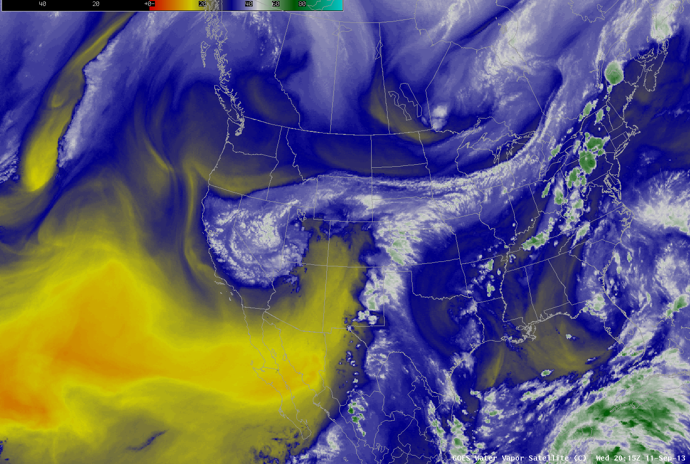
September 12, 2013 Water Vapor Image Loop Courtesy of Colorado Climate Center
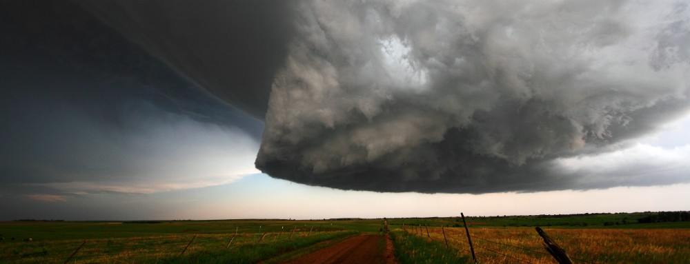
By Mid-September, most people living in the Mountain West were going to remember 2013 for a continued drought from 2012 and horrific wildfires. But those living along the Colorado Front Range might forget the dry heat and fires. Between September 8th and 10th, rain began falling in many areas over the steep terrain of the Colorado Rockies. But by the 11th, that rain became torrential. By the 15th, many locations had received half a year’s worth of rain; and in some areas the all-time daily and monthly records were shattered. Terrifying flash floods and landslides resulted from the record rainfall all over the Central Rockies. Homes, roads, bridges and lives were swept away, stranding thousands and cutting-off entire communities. Many places were accessible only by air or on foot; rescuers had to hike in or arrive by helicopter.
The primary player in this event (the heavy precipitation pattern) could be seen evolving at least a week in advance, if not further. A strong upper-level low over the American Southwest combined with a large ridge over the Eastern U.S. to pump one of the juiciest subtropical airmasses many Coloradans will ever experience. This airmass came up from the Caribbean and into the heart of Rocky Mountains, the virtual rooftop of the Contiguous 48 States. Upslope combined with a stalled cold front created perfect conditions for constant heavy showers and thunderstorms over the Western High Plains deep into the High Country of Colorado, Southern Wyoming, and Northern New Mexico. The pattern was steady and slow to evolve and easy to recognize.
Some locations, including the Front Range town of Boulder, were soaked by 10 to 20 inches of rain in only a few days. 9.08 inches of rain accumulation was measured in Boulder over a 24 hour period–smashing the old record of 4.80 inches. Boulder also broke its all-time monthly rainfall record (17.18 inches) by more than 7 inches and already set a record annual total of 30.14 inches.
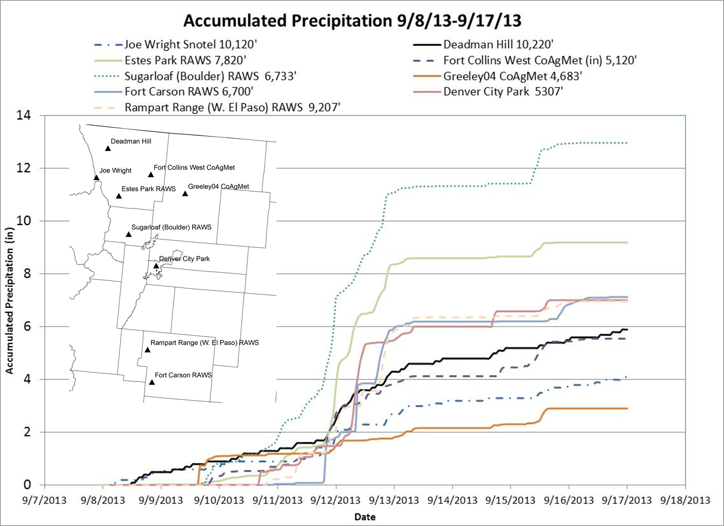
Accumulated Precip Graph Sept 8-17, 2013 Courtesy of Colorado State University
Widespread rainfall totals between 5-20 inches over just several days in any region of the United States will cause terrible flooding, but this was over the Central Rockies of Colorado. The high and rugged mountainous terrain is cut by steep valleys and canyons; the water descends quickly, funnels into narrow passages, rises and moves with tremendous force. As if crazy heavy rainfall over very large mountains wasn’t enough, the prolific drought, which began in Spring of 2012, combined with multiple large and destructive wildfires left many slopes barren, wiping out acres of vegetation. This dramatically increased the threat of mud and rock slides by creating a faster, easier path for water to run off into swollen streams and rivers. The record rainfall over the relatively dry, fire-scarred, and mountainous terrain of Central Colorado was a recipe for disaster. The result was horrific flooding and landslides in the valleys and canyons of the Central Rockies.
Meteorologically speaking, it’s quite common to have this type of cause and effect scenario. The record-breaking drought and wildfires paved the way for potential landslides caused by record rainfall totals.
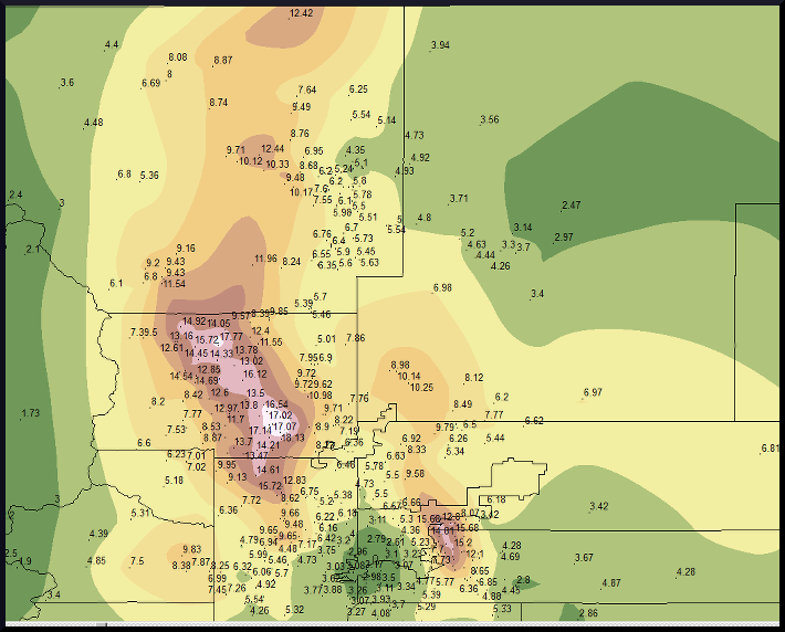
Storm Precip Totals Courtesy of NWS Boulder
The Hydrometeorological Design Studies Center (HDSC) has determined areas like Boulder, CO were affected by a 1 in 1000 year event due to the extreme amount of rainfall, which occurred in a 24 hour period. The findings from the HDSC puts the magnitude of this rainfall/landslide/flooding event into perspective: it was megalithic! The Denver/Boulder National Weather Service Office created a webpage discussing Central Colorado flooding in September of 1938 comparable to the September 2013 event: http://www.crh.noaa.gov/images/bou/precip/Presentation2.pdf
This flood was huge: 1 in 1000 year odds for some areas like Boulder, but, despite being so incredibly rare, is there anything to learn from this devastating event? I believe so. Nearly every location on this planet is under threat of excessive precipitation and resulting floods. No place is exempt from flooding when almost 20 inches of rain falls over a period of several days. It’s a terrible tragedy for many affected in Colorado, Wyoming, and New Mexico. Hopefully, they won’t experience another event like this in their lifetimes. Some people may even think twice about living in an area susceptible to 100 year floods, or maybe even 1000 year floods. The people who live in the narrow valleys and canyons in the foothills and mountains have to make a choice… Some will rebuild, but others may not. The beautiful steep-walled canyons of the Colorado Front Range should be a constant reminder of the floods which dug out such amazing geological gashes in the uplifted rock. Valleys are created very slowly over long periods of time, but canyons are literally gouged from the Earth in a violent fashion. These chasms can be extremely dangerous during a flood because of the steep walls. They’re nearly impossible to climb and offer no help when going up is the only way out.
The Big Thompson River passing through Big Thompson Canyon was badly affected from this event…and reminiscent of the tragedy that struck there on July 31, 1976. Big Thompson Canyon is very narrow with steep rock walls in many places. Route 34 weaves through this deep gully and often there’s only enough room for the road and river. During storms, water falls on the surrounding hills and mountains, then descends rapidly down steep rocky slopes into the washes and streams feeding the Big Thompson River, and with nowhere else to go the flow becomes a raging flood in the narrow canyon carrying boulders, cars and anything else in its path.
The 1976 Big Thompson Canyon Flood is now an infamous case study taught in many meteorologist classes in universities around the country.
Driving through this Canyon in July 2013, I couldn’t help but feel slightly uneasy and a little in awe passing between the shear rock walls along a healthly flowing Big Thompson River–knowing this was the site where more than 140 people were killed in the 1976 flood. It kind of surprised me to see numerous buildings perched on slivers of dry ground wedged between the river’s edge and rock walls on my way to Loveland from Estes Park. I’ve seen way too many people rebuild on a flood plain, or on a beach without proper stilts to protect from the wrath of a hurricane’s storm surge, or in the heart of Tornado Alley without a safe room or storm shelter. Can’t really say, “don’t build there”, because no place on this planet is safe from disaster. We can only hope people will remember, learn, and take proper precautions in disaster-prone areas to protect themselves and their loved ones.
